

GIS for Everyone: Learn GIS and Create Web Maps
GIS for Everyone: Learn GIS and Create Web Maps
English | 2015 | mp4 | H264 1280x720 | AAC 2 ch | 2 hrs | 590 MB
eLearning, IT & Software, Other | Skill level: Beginner level
English | 2015 | mp4 | H264 1280x720 | AAC 2 ch | 2 hrs | 590 MB
eLearning, IT & Software, Other | Skill level: Beginner level
Learn the fundamentals of GIS, web mapping, remote sensing, GPS, and map projections for handling your spatial data.
This GIS (Geographic Information Systems) course is for every professional who is unsure on how to deal with spatial data or is preparing to undertake a job that requires GIS skills.
Many professionals waste considerable time trying to solve GIS related problems because they do not properly understand spatial reference systems, map projections, and techniques to handle and represent spatial data. You will not experience the same after completing this course and you will get up and running with GIS in short time.
You will understand what GIS is by looking at various GIS use cases. You will learn about the various data types and file formats that are used in GIS. You will also learn about GPS and remote sensing data and how they are integrated in GIS. The course also covers the trickiest part of GIS and mapping that is map projections
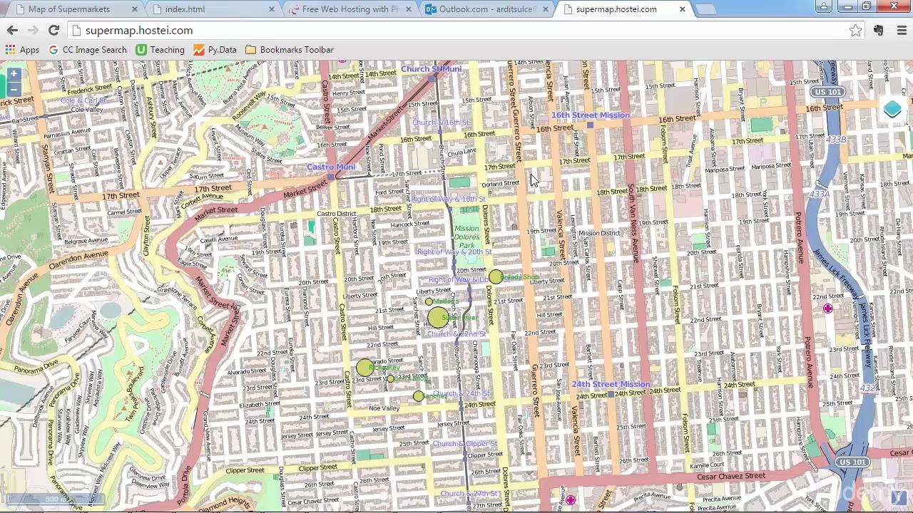
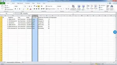
Once you get to know with the theory, you will then be given some raw spatial data and you will create a map using QGIS out of those data. Moreover, you will learn how web mapping works and you will create a web map with QGIS and OpenLayers and publish it online on your own website without using any third party service.
What are the requirements?
- A working computer.
What am I going to get from this course?
- Over 28 lectures and 1.5 hours of content!
- Fully understand a GIS process.
- Open, process and visualize GIS data.
- Build a web map and publish it online.
- Understand and work with map projections.
- Learn how to use QGIS.
What is the target audience?
- Programmers, geologists, biologists, and every professional who deals with spatial data.
- Everyone who wants to learn how to handle GIS, GPS, and remote sensing data.
- Those interested to build a web map.
Screenshots:

GIS for Everyone: Learn GIS and Create Web Maps
GIS for Everyone: Learn GIS and Create Web Maps

GIS for Everyone: Learn GIS and Create Web Maps

GIS for Everyone: Learn GIS and Create Web Maps
