

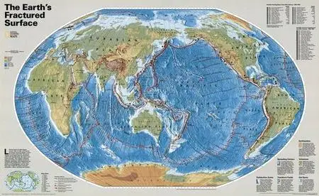
National Geographic Earths Fractured Surface Map

National Geographic Earth's Fractured Surface Map
1 JPG | High resolution | 6000 x 3680 pixels | 10 MB
Like the pieces of a giant jigsaw puzzle, slabs of rocky crust known as tectonic plates fit together to form the earth's outer shell. This map shows the plates in their current configuration, and describes how landforms are reshaped over millions of years through the constant colliding, separating, and scraping of the plates. Also included are sites of major earthquakes since 1906 and notable volcanic eruptions since 1902.
Download
National Geographic Earth's Fractured Surface Map
Other Earth Maps-
National Geographic Earth at Night Map
National Geographic World Physical Ocean Floor
National Geographic World Political Map
National Geographic World Satellite Map
PLEASE NO MIRRORS!
Check My Other Uploads - HERE