

OziExplorer3D v1.12

OziExplorer3D v1.12 | 2.08 Mb
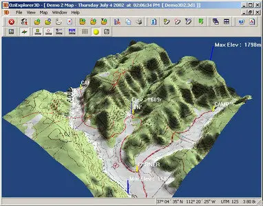
OziExplorer3D is software which allows map images to be viewed in 3D with the ability to rotate in all directions and zoom in and out of the view. When the term OziExplorer3D is used the 3D map viewer is being referred to, when the term OziExplorer is used the OziExplorer GPS Mapping Software is being referred to.
The 3D maps are created using the OziExplorer GPS Mapping Software, the 3D maps are then viewed by OziExplorer3D, in this respect OziExplorer3D can be considered as an add-on to the OziExplorer GPS Mapping software.A 3D map can be created from any map that can be loaded in OziExplorer provided you have elevation data for the region.
A 3D map is composed of a map image (or image part) and a grid of heights at a spacing specified by the user. The software plots the height grid in 3D and then overlays the map image on the grid (this is called texturing) to produce a 3D map.
OziExplorer creates the grid of heights using the height data you have obtained and writes this to a file. Other required information is also written to the file and the file is then passed to OziExplorer3D which loads the file and the map image (or image section) and displays the 3D map.
Main OziExplorer3D Features:
• Display maps in 3D.
• Most maps which can be viewed in OziExplorer can be viewed in 3D (some image types are excluded for licensing reasons).
• Rotate your maps in 3D, view from any direction.
• View waypoints, tracks and points on the 3D map.
• Zoom in and out.
• Apply 3D shading to your map * Apply Fog to the map.
• Load multiple maps in OziExplorer3D (purchased version only).
• Show GPS position on the 3D map.
• Save, copy to the clipboard and print the current 3D map view.
+ much, much more.
Home Page: http://www.oziexplorer3.com/ozi3d/oziexplorer3d.html