

DeltaGIS v8.1.0.8 Multilingual
DeltaGIS v8.1.0.8 Multilingual | 7.1 MB
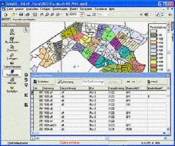
Grapical Management of GPS, Georeferenced Raster Maps and own Vectorizations, Import of ESRI-Shape-, NMEA- and Mororola files; All Infos in a single Area Map; Fast Rendering even of very big Rast Images and optional Display with improved Quality (Halftone/Antialiasing)
Grapical Management of GPS, Georeferenced Raster Maps and own Vectorizations, Import of ESRI-Shape-, NMEA- and Mororola files; All Infos in a single Area Map; Fast Rendering even of very big Rast Images and optional Display with improved Quality (Halftone/Antialiasing), Transparent Mode for Rastermaps - a Feature often missed in other programs; Area splitting and Combining of several Areas to a single Area; Measure Tool, many Search Functions; Manually Editing of Area, Lines, etc.; individual Coloring, Symbols (e.g. tress, stones), Text and freehand drawings; True-of-scale Print in free selectable scale; EU-conform Field Protocol; Recognizes restricted areas automatically
Download Uploading.com
Click Here
Download Hotfile.com
Click Here
Download Filefactory.com
Click Here
No Mirror