

Aquaveo Watershed Modeling System (WMS) 11.0.8

Aquaveo Watershed Modeling System (WMS) 11.0.8 | 2.7 Gb
Aquaveo, a water resources consulting company, is pleased to announce availability Watershed Modeling System (WMS) 11.0.8 is a complete watershed solution used for automated delineation, hydrologic & hydraulic modeling, floodplain mapping, and storm drain modeling.
LIDAR Management
WMS 11.0 now supports advanced LIDAR data handling tools for reading, viewing, and converting LIDAR data to other formats for use with your model. Large LIDAR datasets are efficiently displayed with options to specify the number of points visualized and exclude points outside the extent. WMS 11.0 supports LIDAR data in both Point Cloud and Elevation grid formats and supports converting Point Clouds to Elevation grids.
New Map Flood Tool & Floodplain Delineation
A new map flood tool is available to define a vertical offset from a 100-year floodplain map for analyzing extreme flood scenarios. Modified floodplain maps can be used to determine the impacts of extreme weather and flood scenarios on existing and proposed roadways and other structures. Floodplain delineation in WMS 11.0 is now streamlined and much faster than in previous versions - in many cases by a factor of 10.
Graphics Enhancements
High resolution displays caused icons and text in older versions of WMS to render very small. WMS now detects your display resolution and appropriately sizes icon bitmaps and fonts. Icons may also be sized manually in the Preferences dialog. Additionally, a multisampling level tool has been added for adjusting the anti-aliasing of graphics.
HEC-RAS and HEC-HMS Updates
The most recent versions of HEC-RAS (v5.0.3) and HEC-HMS (v4.2.1) are now supported in WMS 11.0. Importing HEC-RAS GIS (*.sdf) files is now faster and easier to use. Managing and editing cross section databases for HEC-RAS is now easier in WMS. A new dialog is available for selecting, managing, and editing cross sections and cross section databases.
Worldwide Elevation Data
WMS now supports Amazon Terrain Tiles providing high resolution elevation data for the entire world with resolutions as high as 3 meters per pixel.
LandXML Import & Export
Support for reading and writing LandXML files from the hydraulic modeling module for the SWMM, HY12, and EPANET models has been added.
GSSHA Updates
The most recent version of GSSHA (v7.12) is now supported in WMS 11.0.
New & Updated Tutorials
All tutorials for WMS 11.0 have either been re-written or are newly released. As always, our comprehensive tutorials are free to download and provide step-by-step instruction on using WMS.
GIS
- 12312 Crash when loading some *.asc files.
Installer
- 12154 WMS Installer gives error about Hydraulic Toolbox when a previous version of the Hydraulic Toolbox is installed.
Raster
- 11670 DEM resample does nothing. The DEM has the same number of columns and rows as before.
Time Series
- 12373 IDF curve errors in Time Computation Arc Attributes dialogs. The IDF data are not saved when accessed through the Calculate i button in the Time Computation Arc Attributes table.
Aquaveo Watershed Modeling System (WMS) 11.0.8

The Watershed Modeling System (WMS) is a comprehensive environment for hydrologic analysis. It was developed by the Environmental Modeling Research Laboratory of Brigham Young University in cooperation with the U.S. Army Corps of Engineers Waterways Experiment Station. The software is currently being developed by Aquaveo.
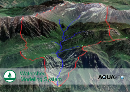
WMS offers state-of-the-art tools to perform automated basin delineation and to compute important basin parameters such as area, slope and runoff distances. It serves as a graphical user interface for several hydraulic and hydrologic models. With its management of coordinate systems, WMS is capable of displaying and overlaying data in real world coordinates. The application also provides many display tools for viewing terrain surfaces and exporting images for reports and presentations.
WMS
Instructional videos for the Watershed Modeling System (WMS) program developed by Aquaveo.
Aquaveo is a pioneer of GIS-based software solutions for hydraulic, hydrologic and groundwater modeling. Our products have been refined over two decades to create the most advanced environmental modeling and visualization software available. In addition to interfacing with industry standard numerical models, we develop custom desktop and cloud-based applications tailored to specific needs.
Aquaveo began as a part of the Engineering Computer Graphics Laboratory at Brigham Young University in 1985. The lab was reorganized and the name was changed in September, 1998 to the Environmental Modeling Research Laboratory (EMRL). In April, 2007, the main software development team at EMRL entered private enterprise as Aquaveo, LLC.
Product: Aquaveo Watershed Modeling System
Version: 11.0.8 with Tutorials
Supported Architectures: x64
Website Home Page : www.aquaveo.com
Language: english
System Requirements: PC *
Size: 2.7 Gb
WMS 11.0 System Requirements
Operating System: Windows 10
RAM: 16GB or more recommended
CPU: WMS software is CPU intensive. Some models and utilities integrated with WMS can take advantage of multiple processor cores simultaneously. We recommend the fastest CPU your budget allows.
Storage: Recommended storage amount will vary depending on individual data requirements. Latest versions of WMS are very disk I/O intensive.
- Mechanical hard drive: Basic performance
- SATA solid state drive: Better performance
- NVMe solid state drive: Best performance
Graphics: A dedicated graphics card is better than integrated graphics. A basic or mid-range nVidia card designed for gaming works best.
Display Resolution: 1920 x 1080 or greater
Please visit my blog
Added by 3% of the overall size of the archive of information for the restoration
No mirrors please

![Aquaveo Watershed Modeling System (WMS) 11.0.8]()
Added by 3% of the overall size of the archive of information for the restoration
No mirrors please
Aquaveo Watershed Modeling System (WMS) 11.0.8
