

Aquaveo Watershed Modeling System (WMS) 11.2.5

Aquaveo Watershed Modeling System (WMS) 11.2.5 | 1.5 Gb
Aquaveo, a water resources consulting company, is pleased to announce availability Watershed Modeling System (WMS) 11.2.5 is a complete watershed solution used for automated delineation, hydrologic & hydraulic modeling, floodplain mapping, and storm drain modeling.
Rational Method
- 14687 WMS crash when trying to double-click basin
Materials
- 14696 WMS Crash when trying to edit in material properties dialog
Projection
- 14701 Problem setting projection when a 2D grid exists in WMS
TIN
- 14657 WMS crash with "Smooth Pits" command
- 14662 WMS Crash with "Vertices->Transform…" option
- 14663 WMS Crash with route point
- 14700 WMS Crash when trying to convert TIN to DEM
Hydrologic Data
- 14688 WMS Crash when editing reach data
- 14690 WMS Crash when clicking channels calculator
- 14695 WMS Crash with travel time
- 14709 WMS Crash when deleting data in HMS properties dialog
- 14738 GUI Test: WMS crashes when zooming after delineating watershed
2D Grid
- 14697 WMS Crash with generating credible intervals
HEC-1
- 14705 WMS Crash when trying to delete rain gage with delete key
- 14758 Probable Maximum Precipitation Percentages Are Being Erased Out of the HEC-1 Precipitation Dialog
Dialogs
- 14689 WMS freezes when trying to delete Stochastic data
Plot
- 14656 WMS items can be clicked without seeing what they are
- 14707 WMS problems after trying to get to Plot Wizard
- 14691 WMS cross sections graph incorrectly adds to the X-Axis
- 14759 WMS issues with various plots
HY-8
- 14714 Edit button does not open HY-8 like it should
File IO
- 14741 WMS crash after reading file
GIS
- 14033 Texture map issue - resolution too low, rips
GSSHA
- 14753 Detention Basins Cause Errors When Loading the GSSHA Solution
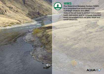
The Watershed Modeling System (WMS) is a comprehensive environment for hydrologic analysis. It was developed by the Environmental Modeling Research Laboratory of Brigham Young University in cooperation with the U.S. Army Corps of Engineers Waterways Experiment Station. The software is currently being developed by Aquaveo. WMS offers state-of-the-art tools to perform automated basin delineation and to compute important basin parameters such as area, slope and runoff distances. It serves as a graphical user interface for several hydraulic and hydrologic models. With its management of coordinate systems, WMS is capable of displaying and overlaying data in real world coordinates. The application also provides many display tools for viewing terrain surfaces and exporting images for reports and presentations.
WMS
Instructional videos for the Watershed Modeling System (WMS) program developed by Aquaveo.
Aquaveo is a pioneer of GIS-based software solutions for hydraulic, hydrologic and groundwater modeling. Our products have been refined over two decades to create the most advanced environmental modeling and visualization software available. In addition to interfacing with industry standard numerical models, we develop custom desktop and cloud-based applications tailored to specific needs. Aquaveo began as a part of the Engineering Computer Graphics Laboratory at Brigham Young University in 1985. The lab was reorganized and the name was changed in September, 1998 to the Environmental Modeling Research Laboratory (EMRL). In April, 2007, the main software development team at EMRL entered private enterprise as Aquaveo, LLC.
Owner: Aquaveo
Product Name: Watershed Modeling System (WMS)
Version: 11.2.5
Supported Architectures: x64
Website Home Page : www.aquaveo.com
Languages Supported: english
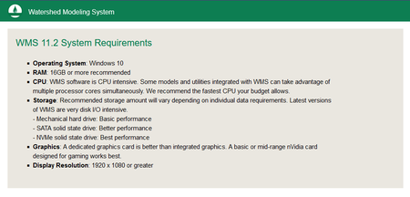
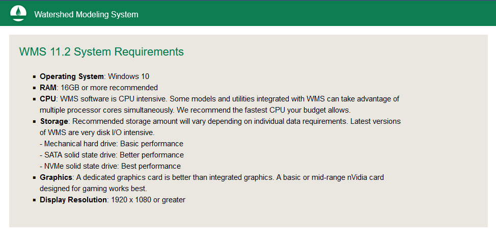
System Requirements: Windows *
Size: 1.5 Gb
Aquaveo Watershed Modeling System (WMS) 11.2.5
Please visit my blog
Added by 3% of the overall size of the archive of information for the restoration
No mirrors please

![Aquaveo Watershed Modeling System (WMS) 11.2.5]()
Added by 3% of the overall size of the archive of information for the restoration
No mirrors please
Aquaveo Watershed Modeling System (WMS) 11.2.5
