

Dundas Map for Reporting Services v1.0.0.514 for SQL Server 2005 Retail
Dundas Map for Reporting Services v1.0.0.514 for SQL Server 2005 Retail | Win32 |Size: 39.18 MB
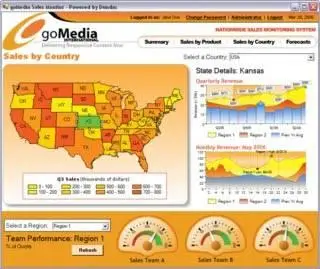
Understanding your data within SQL Reporting Services is pivotal to making better business decisions.? Until now, if you had geographic data that you wish to visualize using SQL Reporting Services, your options used to be limited to simple charts and data grids.? With Dundas Map for Reporting Services, you now have a level of visualization that goes beyond what can be achieved with the standard reports in SQL Reporting Services.
Use it stand-alone, or in conjunction with the other Reporting Services products from Dundas to transform your reports into Click here for more »
stunning Digital Dashboards.Click here for more »
General Features
Easy-to-use design-time designer
Serialize maps as XML or binary
Save maps as image files (jpg, bmp, png)
Geographic grid and projections support
Gradient and hatch styles for all map elements
Map layers
Print support
Detailed samples
Map Visualization
High performance viewport for display of map graphics
Adjustable zoom range and zoom level
Map Designer and Wizard
Predefined maps from a library of base maps
World and Continent Maps
Detailed Country Maps including the USA and Canada
Customizable parallel and meridian grid lines
Configure color swatches, distance scales, and legends
Flexible designer can be launched at any time
Map Import Features
Automatic naming of map elements through data field association
Select multiple data attribute columns for rich map data
Map Projections??? ASP.NET??? Windows Forms
Support for ten of the most widely used map projections
Fully configurable projection parameters such as projection center
Switch projections at any time, including runtime
Map Content Features
Extensive set of appearance and behavioral options
Offset locations and apply scale factors to create exploded views
Automatically group shapes into geographic regions
Automatically colorize and symbolize maps using the rule-based engine
Create chloropeth and proportional symbol maps
Layers
Unlimited number of logical layers for element management and manipulation
Assign map elements to one, all or no layers
Easily show or hide a layer and all of its subsequent elements
Intelligent layer properties show/hide layers based on zoom level
Data Grouping and Classification
Classify map elements using data grouping algorithms
Group or classify elements into equal intervals, equal distribution, or optimally
Automatically assign colors or symbols for each data class
Data Binding
Bind map elements with database tables
Automatically classify and configure map elements based on column values
Map Layout and Composition
Add distance scales, color swatches and legends to maps
Dock and size elements using absolute units or percentages
Insert images into maps for displaying custom graphics
Add labels to maps to create titles and sub-titles
Legend Features
Customizable legend titles
Multi-column legends
Customized cells for full customization of all legend elements
Interlaced rows
Multiple legends per map for increased data potential
Advanced Features
Programmatic access to map elements including shapes
Rapidshare
http://rapidshare.de/files/356...tSrvv100514SQLSvr2005.rar.html
No Password
Best regards,
WebGurru