

geo&soft international ELETOM 32 Version 3.0.13 - Tool for Electrical Tomography
Geo&Soft international ELETOM 32 Version 3.0.13 - Tool for Electrical Tomography
5 MB Compressed RAR File | OS: Windows ALL
What is ELETOM?
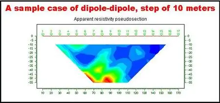
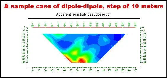
ELETOM is a software that performs complete 2D inversion (and not the simple iterative deconvolution of the pseudo-sections) of surface electrical surveys with any measurement array (Wenner, dipole-dipole, pole-dipole, pole-pole, user defined arrays, mixed arrays) with a maximum of 64 electrode positions that can be added by the user as required.
ELETOM uses the finite elements method (FEM) in two dimensions to model the electrical response of the subsurface.
The elements that define the grid are trapezoidal in form to enable one to compensate any height differences between the electrode positions. The current dispersion in the third spatial dimension (perpendicular to the section of interest) is taken into consideration using Wannamaker's correction.
When using ELETOM it is not necessary to specify any parameter to construct the grid. One only needs to enter the positions and numbering of the electrodes used in the survey measurements.
The iterative algorithm used to perform the inversion is based on the minimisation of the mean square error between field data and the data simulated by the FEM, according to the method proposed by Sasaki (1994).
The convergence of the algorithm is obtained by estimating a stabilisation (performed with the generalised reciprocal coefficients method) which is repeated during every iteration.
The reduction of the noise effect that is present in the data, is obtained through an iterative linear regression calculation (Ward, 1990) that enables one to compensate for the fact that it is impossible to know the statistical variance of each measurement.
The result is given by a precisely reconstructed real resistivity section (in two dimensions) which is equal to the smallest halved inter-electrode distance, with the possibility of selecting a set of colour shadings to enhance the anomalies that are present in the soil in the best possible way. The results can also be rendered as isoresistivity curves.
RAR Password: geoandsoft