

3D Inversion Of Magnetic Data Using Gm-Sys 3D
3D Inversion Of Magnetic Data Using Gm-Sys 3D
Published 9/2025
MP4 | Video: h264, 1920x1080 | Audio: AAC, 44.1 KHz
Language: English | Size: 1.87 GB | Duration: 2h 10m
Published 9/2025
MP4 | Video: h264, 1920x1080 | Audio: AAC, 44.1 KHz
Language: English | Size: 1.87 GB | Duration: 2h 10m
For Mapping Potential Mineralized Zones Using Aeromagnetic Data
What you'll learn
Convert a grid in tif format to Oasis Montaj Grid format
Working in the GM-SYS 3D environment effectively
Understanding Forward and Inverse Modelling
Interpreting 3D modelling results
Requirements
Import and grid data using various file formats: .txt, .csv, .grd. etc.
Description
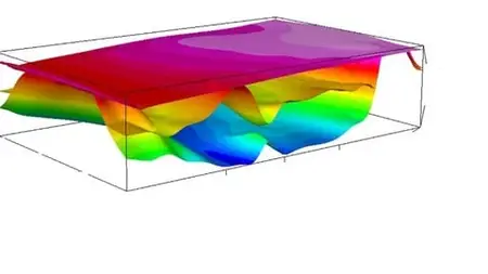
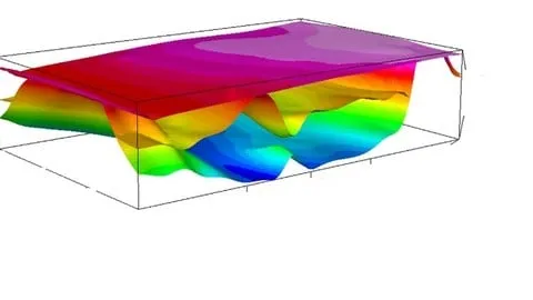
This is a complete course that will take you step by step to master 3D inversion of magnetic data. This process involves using measured magnetic field data to create a three-dimensional model of subsurface structures, often to identify mineral deposits or geological features. The main aim of this 3D inversion process is to determine the distribution of magnetic susceptibility in the Earth's subsurface by solving the inverse problem of forward modeling. The GM-SYS 3D Modelling system is a 3D gravity and magnetic modelling package for surface-oriented models. A model is defined by a number of stacked surface grids with density, susceptibility and remanent magnetization distributions specified for the layer below each surface.3D models are defined by a number of surface grids with a density distribution (and/or susceptibility & remanent magnetization distribution) assigned to each layer. Layer density may be specified using either a constant density, a vertical density-depth profile relative to a reference surface, or a laterally-varyingdensity distribution defined by a grid. Layer susceptibility may be specified using either a constant susceptibility and remanent magnetization, or a laterally-varying susceptibility distribution.All input grids must also be consistent with respect to the following:– Grid size (number of rows and columns).– Coordinate system.– Cell size and units.– Grid origin/location.
Overview
Section 1: Introduction
Lecture 1 Introduction
Section 2: Producing Topography Grid
Lecture 2 Producing Topography Grid
Section 3: Producing Depth to Basement Map
Lecture 3 Part A
Lecture 4 Part B
Lecture 5 Part C
Section 4: Create 3D Model and Add Layers
Lecture 6 Create 3D Model and Add Layers
Section 5: Adding and Configure Magnetic Survey
Lecture 7 Adding and Configure Magnetic Survey
Section 6: Run the 3D Forward Modelling and Export Anomaly Grids
Lecture 8 Run the 3D Forward Modelling and Export Anomaly Grids
Section 7: Run the 3D Inversion Process
Lecture 9 Run the 3D Inversion Process
Section 8: Extract 3D inversion Results and Plot Map
Lecture 10 Extract 3D inversion Results and Plot Map
Section 9: Export 3D inversion Results as Image Files
Lecture 11 Export 3D inversion Results as Image Files
Section 10: Extract 2D Profile Results From 3D Inverted Model
Lecture 12 Extract 2D Profile Results From 3D Inverted Model
Researchers looking for ways to how to model geophysical data in GM-SYS 3D