Learning the FOSS4g Stack: Python for Geospatial
Learning the FOSS4g Stack: Python for Geospatial
Video: .mp4 (1280x720, 30 fps(r)) | Audio: aac, 44100 Hz, 2ch | Size: 2.33 GB
Genre: eLearning Video | Duration: 29 lectures (4h 57m) | Language: English
leverage geospatial tasks with Python programming
Video: .mp4 (1280x720, 30 fps(r)) | Audio: aac, 44100 Hz, 2ch | Size: 2.33 GB
Genre: eLearning Video | Duration: 29 lectures (4h 57m) | Language: English
leverage geospatial tasks with Python programming
What you'll learn
You will learn how to write basic Python scripts.
You will also learn how to integrate Python packages that have GIS functionality.
As a bonus, this course will also show how to use Arcpy, and integrate ArcGIS with FOSS4g.
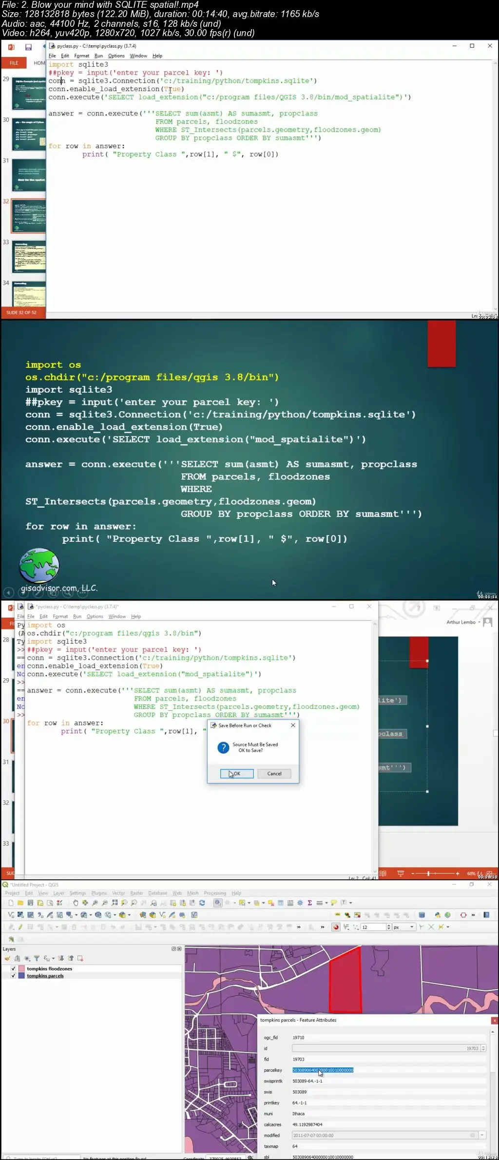
And you'll learn how to integrate SQL, PostGIS, and SpatiaLite.
Requirements
Students should be comfortable with computers and GIS software
It would help if you've done a little programming, but even if you haven't we've got you covered. Students with Python experience can skip the introductory sections, and jump right to the spatial stuff.
Description
If you are in the field of GIS, you're probably hearing everyone talking about Python, whether it's Arcpy in ArcGIS or special Python packages for doing things like geocoding. In this course I am going to show you how to write Python code to perform spatial analysis. The course isn't so much about learning Python, but rather how to integrate different spatial libraries within your Python code. Using the course videos, you will work alongside of me to learn how I go about cobbling together Python code and various packages to solve spatial problems. I'll provide you with all the data that I demonstrate in the course.
Of course, we'll have a brief overview of Python. But after the brief refresher, we will dive into using Python with Open Source GIS and commercial GIS software. Most courses only go over a single GIS program's use of Python. But in this class, you'll get exposed to all kinds of different GIS software products, and learn how to tie them all together with Python.
Who this course is for:
Students who want to expand their geospatial skills to include Python programming.
Students who want to learn how to integrate Python, QGIS, ArcGIS, Postgres, and cloud-based spatial data services togethe.r into a unified solution.
Students looking to nail that next interview that requires you to know something about GIS and scripting.
Learning the FOSS4g Stack: Python for Geospatial