

TTC Video - The Science of Extreme Weather
TTC Video - The Science of Extreme Weather
Course No. 1771 | .M4V, AVC, 400 kbps, 640x360 | English, AAC, 128 kbps, 2 Ch | 24x30 mins | + PDF Guidebook | 2.2 GB
Lecturer: Eric R. Snodgrass, Director of Undergraduate Studies for the Department of Atmospheric Sciences
Course No. 1771 | .M4V, AVC, 400 kbps, 640x360 | English, AAC, 128 kbps, 2 Ch | 24x30 mins | + PDF Guidebook | 2.2 GB
Lecturer: Eric R. Snodgrass, Director of Undergraduate Studies for the Department of Atmospheric Sciences
Extreme weather captures our attention, perhaps now more than ever. Great writers and artists have depicted it in powerful works such as Shakespeare’s The Tempest and Winslow Homer’s The Gale. Movies such as The Perfect Storm, Twister, and The Day After Tomorrow entertain—and terrify—us. Weather apps, websites, and TV channels alert us to our local weather around the clock and also warn us about severe weather.
And yet, we can’t control the weather. Indeed, its most extreme forms plunge us into a struggle for survival, in catastrophic events such as these:
In January 1888, a thaw on the Great Plains was followed by a sudden temperature drop and a blinding blizzard, trapping many children in one-room schoolhouses, miles from home, without adequate clothing. The “Children’s Blizzard” claimed 235 lives.
In July 1976, a typical afternoon thunderstorm in the Rocky Mountains lacked the usual wind shear to keep it moving. The result was a stationary deluge that initiated a flash flood in the Big Thompson River, killing 144 who could not outrun the rapidly rising water.
During just a few days in August 2005, Hurricane Katrina evolved from a cluster of ordinary storms into a monstrous hurricane that left more than 1,200 dead and ranks as America’s costliest natural disaster to date.
We may be helpless to prevent such weather, but thanks to an ongoing revolution in the science of meteorology, we can now understand how extreme weather conditions arise, extract far more useful information from forecasts, and know how to protect ourselves when dangerous conditions develop.
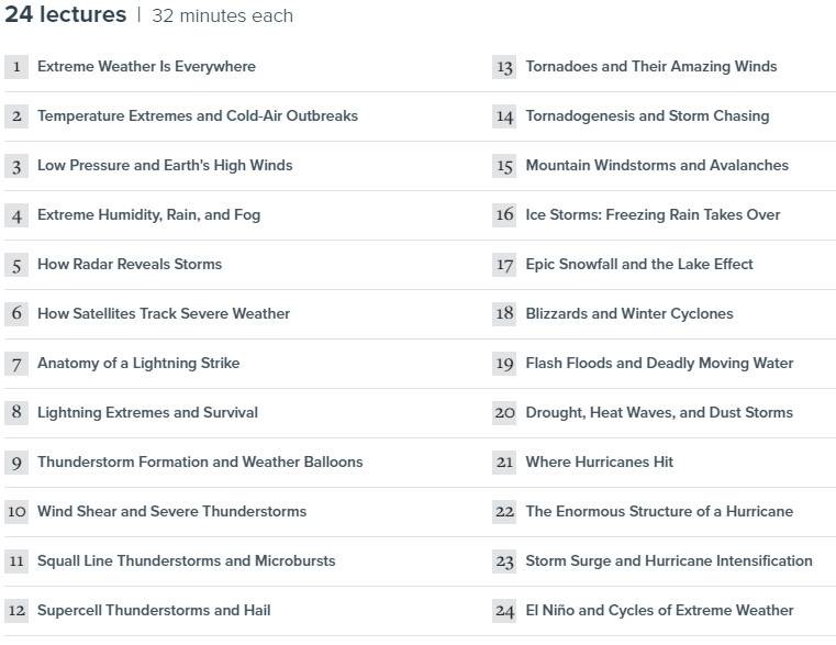
The Science of Extreme Weather is your field guide to the worst that Earth’s atmosphere can inflict. In 24 exciting, informative, and potentially life-saving half-hour lectures aimed at weather novices and amateur forecasters alike, you gain a surprisingly powerful tool in the face of such overwhelming forces: knowledge.
Guided by meteorologist, storm chaser, and award-winning teacher Eric R. Snodgrass of the University of Illinois at Urbana-Champaign, you learn the fundamental science that underlies blizzards, flash floods, hurricanes, tornadoes, heat waves, and more. Never again will you under- or overreact in the face of an emergency weather “watch” or “warning,” because you’ll understand the difference between the two, the nature of the impending threat, the reasoning behind the prediction, and the measures you need to take for protection.
Think Like a Meteorologist
Illustrated with beautifully rendered graphics, stunning storm images, and entertaining demonstrations of meteorological principles, The Science of Extreme Weather teaches you to think like a meteorologist. In search of potentially life-threatening conditions, you learn to interpret clues in the sky and the significance of temperature, pressure, humidity, and wind direction and speed. Simple and practical forecasting rules, such as that falling air pressure signals stormy weather and rising air pressure heralds clear skies, will suddenly make perfect sense. You’ll also learn to decipher technical data, such as Doppler radar images, which provide velocity information on the motion of precipitation inside storms—like an X-ray into the shrouded birthplace of tornadoes.
In addition, you will be enlightened about widespread extreme weather myths, such as that lightning never strikes twice in the same place, or that a ditch or an underpass are safe refuges if you are caught in the open near a tornado (instead, stay in the car, where the seat belt and airbags will help protect you). And you will be alerted to some truly ominous warning signs, including these:
Lightning: If you are ever outdoors in stormy weather and your skin starts to tingle and your hair stands on end, you are about to be struck by lightning. If you can’t take shelter immediately, then crouch down on the balls of your feet. Don’t run and don’t lie down.
Flooding: Climb to higher ground instead of trying to outrun a flash flood—and never enter a flooded roadway. Six inches of swiftly moving water can sweep you off your feet. Two feet of floodwater can carry away a car. Even if the water doesn’t look too deep, the road could be eroding from beneath, making it prone to collapse under the weight of a vehicle.
Heat and humidity: Heat-related fatalities may well be the deadliest form of weather on Earth. And when combined with high humidity, even seemingly bearable temperatures can kill, due to the body’s inability to cool off. Know the symptoms of heat exhaustion and heat stroke.
Explore the World’s Wildest Weather
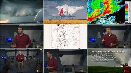
Raised in the heart of Tornado Alley, the region of the U.S. with by far the most tornadoes of anyplace on the planet, Professor Snodgrass has long been fascinated with the supercell thunderstorms that sweep across the plains, spawning tornadoes when a precise combination of meteorological factors coincides. This interest led him to become a scientist and storm chaser—a cautious stalker of extreme weather, using the tools of his discipline to decipher what makes dangerous storms form. Each year he leads more than 1,500 University of Illinois students through a course focused on severe and hazardous weather.
In The Science of Extreme Weather, this exuberant meteorologist and gifted educator takes you on a virtual expedition into the heart of the world’s wildest weather, investigating the mechanisms behind storms such as these:
Tornadoes, class EF5: Tornado wind speeds can range from 65 mph to more than 200 mph. The Enhanced Fujita (EF) scale classifies the most destructive as EF5. Professor Snodgrass explains how tornadoes achieve such strength, highlighting the history of several of the deadliest.
Tropical cyclones: A typical tornado is 100 feet wide, while a tropical cyclone (called a hurricane in the Atlantic and a typhoon in Japan) is hundreds of miles wide. Major Atlantic hurricanes are those in category 3, 4, or 5, with sustained winds of 111 to 157 mph or higher.
Lake-effect snowfalls: The region downwind of the Great Lakes routinely experiences epic snowfalls, with a 2014 storm burying parts of Buffalo, N.Y., in 5 to 7 feet of snow over the course of several hours. Professor Snodgrass describes how cold air flowing over a relatively warm lake incited this paralyzing event.
All of these extremes, and many more that you learn about in this course, may make it seem that our planet is barely survivable. But as Professor Snodgrass points out, we thrive on Earth. Even as the population of the globe continues to increase, fewer and fewer people are dying from extreme weather. The credit goes to improved forecasting tools along with more accurate computer models that weigh the countless data points that represent the ever-changing atmosphere. As a result, it is rare for a severe weather event to catch meteorologists by surprise.
Extreme weather has another side: it is nature’s way of restoring balance. For example, tropical cyclones in the Atlantic and Pacific are fundamental to Earth’s energy and water budget. They act as a safety valve for high levels of temperature, moisture, and pressure that would become much worse without such storms. After watching The Science of Extreme Weather, you’ll come away with newfound appreciation and respect for the atmosphere’s most awe-inspiring phenomena.
In January 1888, a thaw on the Great Plains was followed by a sudden temperature drop and a blinding blizzard, trapping many children in one-room schoolhouses, miles from home, without adequate clothing. The “Children’s Blizzard” claimed 235 lives.
In July 1976, a typical afternoon thunderstorm in the Rocky Mountains lacked the usual wind shear to keep it moving. The result was a stationary deluge that initiated a flash flood in the Big Thompson River, killing 144 who could not outrun the rapidly rising water.
During just a few days in August 2005, Hurricane Katrina evolved from a cluster of ordinary storms into a monstrous hurricane that left more than 1,200 dead and ranks as America’s costliest natural disaster to date.
We may be helpless to prevent such weather, but thanks to an ongoing revolution in the science of meteorology, we can now understand how extreme weather conditions arise, extract far more useful information from forecasts, and know how to protect ourselves when dangerous conditions develop.
The Science of Extreme Weather is your field guide to the worst that Earth’s atmosphere can inflict. In 24 exciting, informative, and potentially life-saving half-hour lectures aimed at weather novices and amateur forecasters alike, you gain a surprisingly powerful tool in the face of such overwhelming forces: knowledge.
Guided by meteorologist, storm chaser, and award-winning teacher Eric R. Snodgrass of the University of Illinois at Urbana-Champaign, you learn the fundamental science that underlies blizzards, flash floods, hurricanes, tornadoes, heat waves, and more. Never again will you under- or overreact in the face of an emergency weather “watch” or “warning,” because you’ll understand the difference between the two, the nature of the impending threat, the reasoning behind the prediction, and the measures you need to take for protection.
Think Like a Meteorologist
Illustrated with beautifully rendered graphics, stunning storm images, and entertaining demonstrations of meteorological principles, The Science of Extreme Weather teaches you to think like a meteorologist. In search of potentially life-threatening conditions, you learn to interpret clues in the sky and the significance of temperature, pressure, humidity, and wind direction and speed. Simple and practical forecasting rules, such as that falling air pressure signals stormy weather and rising air pressure heralds clear skies, will suddenly make perfect sense. You’ll also learn to decipher technical data, such as Doppler radar images, which provide velocity information on the motion of precipitation inside storms—like an X-ray into the shrouded birthplace of tornadoes.
In addition, you will be enlightened about widespread extreme weather myths, such as that lightning never strikes twice in the same place, or that a ditch or an underpass are safe refuges if you are caught in the open near a tornado (instead, stay in the car, where the seat belt and airbags will help protect you). And you will be alerted to some truly ominous warning signs, including these:
Lightning: If you are ever outdoors in stormy weather and your skin starts to tingle and your hair stands on end, you are about to be struck by lightning. If you can’t take shelter immediately, then crouch down on the balls of your feet. Don’t run and don’t lie down.
Flooding: Climb to higher ground instead of trying to outrun a flash flood—and never enter a flooded roadway. Six inches of swiftly moving water can sweep you off your feet. Two feet of floodwater can carry away a car. Even if the water doesn’t look too deep, the road could be eroding from beneath, making it prone to collapse under the weight of a vehicle.
Heat and humidity: Heat-related fatalities may well be the deadliest form of weather on Earth. And when combined with high humidity, even seemingly bearable temperatures can kill, due to the body’s inability to cool off. Know the symptoms of heat exhaustion and heat stroke.
Explore the World’s Wildest Weather
Raised in the heart of Tornado Alley, the region of the U.S. with by far the most tornadoes of anyplace on the planet, Professor Snodgrass has long been fascinated with the supercell thunderstorms that sweep across the plains, spawning tornadoes when a precise combination of meteorological factors coincides. This interest led him to become a scientist and storm chaser—a cautious stalker of extreme weather, using the tools of his discipline to decipher what makes dangerous storms form. Each year he leads more than 1,500 University of Illinois students through a course focused on severe and hazardous weather.
In The Science of Extreme Weather, this exuberant meteorologist and gifted educator takes you on a virtual expedition into the heart of the world’s wildest weather, investigating the mechanisms behind storms such as these:
Tornadoes, class EF5: Tornado wind speeds can range from 65 mph to more than 200 mph. The Enhanced Fujita (EF) scale classifies the most destructive as EF5. Professor Snodgrass explains how tornadoes achieve such strength, highlighting the history of several of the deadliest.
Tropical cyclones: A typical tornado is 100 feet wide, while a tropical cyclone (called a hurricane in the Atlantic and a typhoon in Japan) is hundreds of miles wide. Major Atlantic hurricanes are those in category 3, 4, or 5, with sustained winds of 111 to 157 mph or higher.
Lake-effect snowfalls: The region downwind of the Great Lakes routinely experiences epic snowfalls, with a 2014 storm burying parts of Buffalo, N.Y., in 5 to 7 feet of snow over the course of several hours. Professor Snodgrass describes how cold air flowing over a relatively warm lake incited this paralyzing event.
All of these extremes, and many more that you learn about in this course, may make it seem that our planet is barely survivable. But as Professor Snodgrass points out, we thrive on Earth. Even as the population of the globe continues to increase, fewer and fewer people are dying from extreme weather. The credit goes to improved forecasting tools along with more accurate computer models that weigh the countless data points that represent the ever-changing atmosphere. As a result, it is rare for a severe weather event to catch meteorologists by surprise.
Extreme weather has another side: it is nature’s way of restoring balance. For example, tropical cyclones in the Atlantic and Pacific are fundamental to Earth’s energy and water budget. They act as a safety valve for high levels of temperature, moisture, and pressure that would become much worse without such storms. After watching The Science of Extreme Weather, you’ll come away with newfound appreciation and respect for the atmosphere’s most awe-inspiring phenomena.
TTC Video - The Science of Extreme Weather
TTC Video - The Science of Extreme Weather
