

Drone Data Processing
Drone Data Processing
Published 6/2025
MP4 | Video: h264, 1920x1080 | Audio: AAC, 44.1 KHz
Language: English | Size: 4.60 GB | Duration: 3h 55m
Published 6/2025
MP4 | Video: h264, 1920x1080 | Audio: AAC, 44.1 KHz
Language: English | Size: 4.60 GB | Duration: 3h 55m
Drone data processing
What you'll learn
Introduction to course
Principal of Cartography
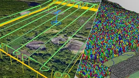
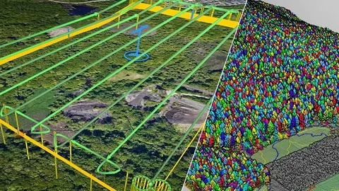
Planning a drone mission in UGCS
Allign photo in Metashape e Cloudcompare
Requirements
No experience
Point Cloud
Description
The course is aimed at technicians and professionals and those who are approaching the world of aerial surveys with drones for the first time. It is divided into nine modules in which the basic principles of surveying with drones will be illustrated, starting from the concepts of flight and planning of flight missions. In Explanation 2 we will talk about the essential concepts of cartography, projection systems and how these must be correctly applied to surveying with drones and in combination with GPS positioning techniques. In the following chapters, once the survey part and the acquisition methodologies have been completed, we will proceed to illustrate the data processing techniques, from checking the percentage of Overlap, to comparing the Ground Control Points beaten with GPS and those detected by GPS; The alignment of the images and the virtualization processes will proceed with the other processes of creating the point cloud. In modules five, six, seven and eight we will analyze the techniques used by commercial software (such as Metashape,DroneDeploy, etc. ) and Free com CloudCompare, to select, filter and classify the point cloud. From now on, the main settings and steps to be performed in CloudCompare and Metashape will be the export of the point cloud and the creation of digital terrain models, complete or spurious, DSM surface only and export of a contour line model to be displayed in Google Earth. Last module dedicated to cost-benefit analysis.
Overview
Section 1: Introduction
Lecture 1 Presentation
Section 2: Basic Concept of Cartography
Lecture 2 Lesson2
Section 3: Prepare a drone Mission
Lecture 3 Drone Survey Mission Plan
Section 4: Allign Photo in Metashape e Cloudcompare
Lecture 4 Allign Photo in Metashape
Section 5: Using Cloud Compare to Select and Extract Fetaures
Lecture 5 CloudCompare to Drone Data
Section 6: From Point Cloud to Depth Maps in Metashape
Lecture 6 Depth Maps in Metashape
Section 7: From Point Cloud To Digital Terrain In Metashape
Lecture 7 Convert Point Cloud to DSM Model
Section 8: Ortomosaic Image from Drone Data in Metashape
Lecture 8 Ortomosaic Image from Drone Data in Metashape
Section 9: Economical Aspect of Drone Tequinique
Lecture 9 Drone Tequinique
Geologist,Engeenering,Architet